
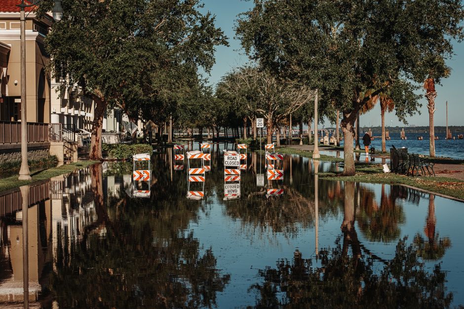
Houston floods often, and its flat terrain, clay soils, and rapid development are the main reasons. The city sits on a coastal plain that drains slowly, and when heavy rain falls, the water has nowhere to go quickly. To check if your area is flooding, you can use the Harris County Flood Warning System, check real-time rainfall data, and monitor local news and road closure maps.
Why Does Houston Flood So Often?
Houston’s geography works against it. The city is built on a flat, low-lying coastal prairie. The land slopes toward the Gulf of Mexico at a very gentle rate, roughly one foot per mile in many areas. That means floodwater moves slowly and tends to pool rather than drain away quickly.
The soil underneath Houston is mostly heavy clay. Clay does not absorb water well. During heavy rain, the ground becomes saturated fast, and the rest of the water runs off across the surface. This is different from sandy or loamy soils that soak up rainfall like a sponge.
Development has made the problem worse. As Houston grows, more land is covered with roads, parking lots, and rooftops. These surfaces are impervious, meaning water cannot soak into the ground. Every new development sends more rainwater into the bayous and drainage systems.
Houston also sits in a region prone to intense rain events. Tropical storms and hurricanes can stall over the area, dropping enormous amounts of rain in a short time. The city has experienced several record-breaking floods in recent years, and the pattern is not going away.
What Makes Houston Flooding Different From Other Cities?
Most cities flood when rivers overflow their banks. Houston is different. Much of its flooding is what engineers call pluvial flooding — flooding caused directly by rainfall, not by overflowing rivers.
Houston has a network of bayous, which are slow-moving, shallow waterways. These bayous are designed to carry stormwater away from neighborhoods. But during extreme rainfall, the bayous fill up and overflow. When that happens, water spreads across the flat land and stays there.
Another difference is that Houston has no zoning laws. This has allowed buildings to be constructed in flood-prone areas, including inside the 100-year floodplain. Many homes were built before flood maps were updated, and some residents are unaware of their flood risk until water enters their home.
The city’s infrastructure also ages under stress. Many of the drainage channels and storm sewers were built decades ago, designed for smaller rain events than the ones Houston now experiences. Climate change is increasing the intensity of rainfall, and the infrastructure has not caught up.
How Do I Check If My Area Is Flooding Right Now?
Real-time information is available, and you should use multiple sources during a storm.
The Harris County Flood Warning System is the most reliable tool. It shows live rainfall totals, bayou water levels, and road closure information across the county. You can view it online or through the mobile app.
Check the National Weather Service for flash flood warnings and radar imagery. Their alerts are issued for specific areas and will tell you if your neighborhood is under a warning.
Local news stations provide continuous updates during major storms. They show live footage of flooding and report road closures as they happen. The Texas Department of Transportation also maintains a map of highway closures.
If you live outside Harris County, check your county’s flood control district website. Fort Bend, Montgomery, and Brazoria counties each have their own monitoring systems.




How Do I Know If My Home Is In A Flood Zone?
FEMA publishes flood maps that show which areas are at risk. These maps are called Flood Insurance Rate Maps (FIRMs). They divide areas into zones based on the likelihood of flooding.
You can look up your address on the FEMA Flood Map Service Center website. Enter your address, and the map will show your flood zone designation. Areas labeled with letters like A, AE, or VE are in high-risk zones. Areas labeled X are considered moderate to low risk.
Keep in mind that flood maps are not perfect. They are updated periodically, but they cannot predict every flood. Many homes that flooded in recent Houston storms were outside the mapped high-risk zones. If you live near a bayou or in a low-lying area, your risk may be higher than the map suggests.
Your mortgage lender may also require a flood determination. If you have a federally backed mortgage and your home is in a high-risk zone, you are required to carry flood insurance. But even if you are not required, flood insurance is worth considering. Standard homeowners insurance does not cover flood damage.
What Does A Flood Watch Versus A Flood Warning Mean?
These terms are used by the National Weather Service, and they mean different things.
A flood watch means conditions are favorable for flooding. It does not mean flooding is happening. It means you should be prepared and stay alert. Watches are issued hours before heavy rain is expected to arrive.
A flood warning means flooding is happening or will happen soon. If a warning is issued for your area, you need to take action immediately. Move to higher ground and avoid driving through flooded roads.
A flash flood warning is the most urgent. Flash flooding occurs within six hours of heavy rain, often within just a few hours. It happens quickly and can be deadly. If a flash flood warning is issued, do not wait. Move to higher ground immediately.
During Hurricane Harvey in 2017, many deaths occurred because people drove into flooded roads. The water can be deeper and more dangerous than it looks. Six inches of fast-moving water can knock over an adult. Twelve inches can carry away a small car. Eighteen inches can move most vehicles.
What Should I Do Before, During, And After A Flood?
Preparation is the best protection. Before hurricane season, which runs from June through November, take steps to protect your home and family.
Know your evacuation routes. Keep important documents in a waterproof container. Have a go-bag ready with medications, cash, phone chargers, and a change of clothes. Make a plan for your pets.
During a flood, never walk or drive through floodwater. Turn around and find another route. If water rises around your vehicle, abandon it and move to higher ground. Move to the highest level of your home if you cannot leave. Do not go into an attic unless you have a way to break through the roof.
After the water recedes, be careful. Floodwater is often contaminated with sewage and chemicals. Wear protective clothing and boots. Do not turn on electrical equipment that got wet. Take photos of damage for insurance claims before you start cleaning up.
Mold can begin growing within 24 to 48 hours after water exposure. Remove wet materials like drywall, carpet, and insulation quickly. If you have health conditions like asthma, consider hiring a professional for cleanup.
Is Houston Getting Better At Managing Floods?
Houston has invested billions of dollars in flood mitigation since Hurricane Harvey. The Harris County Flood Control District has completed dozens of projects to widen bayous, create detention basins, and improve drainage.
One major project is the Addicks and Barker Reservoirs expansion. These reservoirs were built in the 1940s to protect downtown Houston from flooding. They were not designed for the intense storms Houston now experiences. The US Army Corps of Engineers has been raising the dams and improving the spillways.
However, these projects cannot eliminate flooding entirely. They reduce the severity of floods, but they cannot stop water from falling on the ground. There is no engineering solution that can fully protect a city built on a floodplain.
Some neighborhoods are also being bought out and converted to green space. This is a slow process, but it removes homes from the most dangerous areas and allows the land to absorb water naturally.
The honest answer is that Houston is better prepared than it was a decade ago, but the risk remains. Anyone living in the region should understand their personal flood risk and have a plan.
Frequently Asked Questions
How can I check if my Houston street is flooding?
Use the Harris County Flood Warning System website or app for real-time rainfall, bayou levels, and road closure data. Local news stations also provide live updates during storms.
What is the safest way to drive during Houston flooding?
Do not drive through water on the road. Turn around and find an alternate route, because six inches of moving water can knock you off your feet and twelve inches can move a car.
Is my home in a flood zone in Houston?
Check your address on the FEMA Flood Map Service Center website to see your official flood zone designation. Homes near bayous and in low-lying areas face higher risk even if they are not on the map.
Does homeowners insurance cover flood damage in Houston?
No, standard homeowners insurance does not cover flood damage. You need a separate flood insurance policy through the National Flood Insurance Program or a private insurer.